 Religious geometry in prehistory
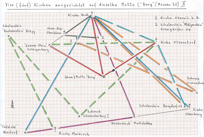
This study deals with the fifth church in the Canton of Berne (Switzerland) Utzenstorf which is directed with 55.4° at the (now disappeared) motte 'Burg'/Messen SO
(601.300/214.605) backwards.
This is not exceptional, as has been demonstrated in the earlier study Geheimnisvolle Ausrichtungen der Kirchen (Berner
Seeland).
In this area is also the church in Burgdorf BE which is directed (108.3°) backwards at the churches of Messen SO and Diessbach BE (see book Religioese Geometrie in der Urgeschichte, p.136), which leads again to significant geometric relations.
The motte 'Burg' was equidistant (9.08 km, always measured horizontally) from the church Utzenstorf, from the church in Arch BE and from the fairly sizeable erratic block 'Grauer Stein' on
'Dotzigenberg' (593.411/219.243). It is remarkable that this erratic block, although not showing clear traces of human action, bears a name and has been put under protection already quite
early.
The church Utzenstorf is then equidistant (10.15 km) from the church Arch and from the cup stone Burgdorf 01 (613.127/210.172), which had already a prominent place in the previous study I. The
same distance a third time between church Arch and the church Vauffelin BE (outside diagram).
The church Arch is equidistant (18.92 km) from this cup stone and from the earthwork 'Gisnaufluh'/Burgdorf (614.870/212.175), and this again from the church Arch and from the church Oberwil
b.Bueren (see also study I).
The straight line church Arch - church Oberwil leads exactly to the big erratic block 'Tuefelstei' ('Devil's stone')/Seedorf BE (589.850/206.400), not to be confounded
with the former 'Tuefelstei' of Meikirch BE in the previous study I.
The church Arch is then equidistant (19.63 km) from 'Tuefelstei'/Seedorf and from the church in Oberburg BE. The resulting straight line 'Tuefelstei' - church Oberburg
goes precisely across the former mediaeval tower 'Heidenstock' in Mattstetten BE (605.760/208.710), today a stately farm house (see photo). It is interesting to note that the name 'Heiden-'
(Pagan) seems to establish a relationship to a pre-christian (prehistoric) "predecessor monument".
'Heidenstock' is in turn equidistant (15.99 km) from 'Tuefelstei'/Seedorf and from the church Arch and forms thereby a so-called "closed triangle network" which is hardly accidental.
The church Utzensdorf is equidistant (15.52 km) from 'Grauer Stein' and from the earthwork 'Schwandenberg I'/Muenchenbuchsee BE (597.705/208.765). One finds the same distance again twice and
interconnected between earthwork 'Schwandenberg I' and the cup stone 'Dachsenstein' Bruegg BE 02 (587.459/220.543) and between this cup stone and the church Meikirch (see study I).
The straight line 'Grauer Stein' - church Arch goes exactly through the former chapel Oberbueren/Bueren a.A. BE (595.550/220.715); this chapel was equidistant (4.92 km)
from church Arch and from the very big cup stone block 'Roedigerstein' Hessigkofen SO 04 (600.500/220.320).
Outside the diagram: church Arch equidistant from 'Grauer Stein' and from church Pieterlen BE; 'Grauer Stein' equidistant from church Pieterlen and from earthwork/former castle
'Rapperstuebli'/Balm b. Messen SO.
Also outside the diagram: church Arch equidistant from 'Roedigerstein' and from chapel Altreu/Selzach SO; 'Roedigerstein' equidistant from chapel Altreu and from cup stone 'Hubelstei' Nennigkofen
SO 01(603.260/226.175) <which shows interesting "whetting grooves", little noticed until now>, and the straight line 'Hubelstei' - 'Roedigerstein' leads precisely to
'Rapperstuebli' !
As for the four churches in the previous study I, the orientation of the church Utzenstorf leads to significant geometric relations. Equidistances over relatively long stretches (15 - 20 km) seem
to give here an "archaic" impression; however, if they are older than shorter ones remains for the moment only a hypothesis.

Write a comment